Neue Deutschland-Aufnahmen in Google Earth
![Karten-Update in Google Earth (Screenshot: t-online.de) Karten-Update in Google Earth (Screenshot: t-online.de)](https://images.t-online.de/2022/04/43797204v1004/0x0:600x450/fit-in/600x0/karten-update-in-google-earth-screenshot-t-online-de.jpg)
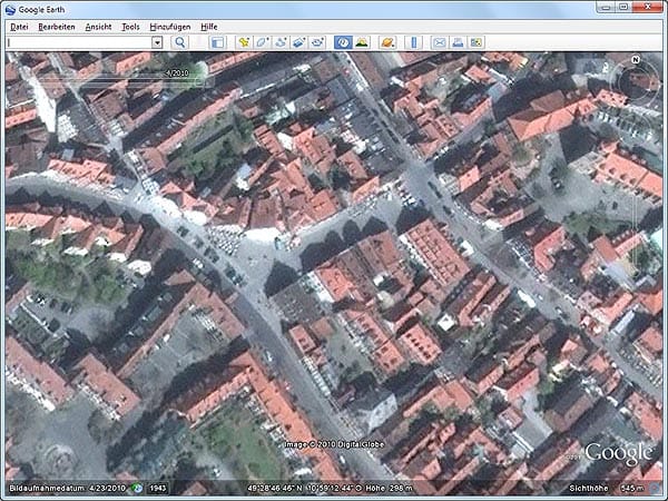
Die Region rund um Fürth zeigt sich in aktuellen Aufnahmen vom April 2010. Allerdings sehen hochauflösende Fotos anders aus - bei 500 Meter Höhe ist Schluss.
![Karten-Update in Google Earth (Screenshot: t-online.de) Karten-Update in Google Earth (Screenshot: t-online.de)](https://images.t-online.de/2022/04/43797730v1003/0x0:600x450/fit-in/600x0/karten-update-in-google-earth-screenshot-t-online-de.jpg)
Zum Vergleich: Fürth vor dem Karten-Update vom Dezember 2010.
![Karten-Update in Google Earth (Screenshot: t-online.de) Karten-Update in Google Earth (Screenshot: t-online.de)](https://images.t-online.de/2022/04/43797746v1004/0x0:600x450/fit-in/600x0/karten-update-in-google-earth-screenshot-t-online-de.jpg)
Ebenfalls keine Augenweide: Die Stadt Ilmenau in Thüringen nach dem Karten-Update vom Dezember 2010.
![Karten-Update in Google Earth (Screenshot: t-online.de) Karten-Update in Google Earth (Screenshot: t-online.de)](https://images.t-online.de/2022/04/43797760v1003/0x0:600x450/fit-in/600x0/karten-update-in-google-earth-screenshot-t-online-de.jpg)
Der Vergleich mit der Aufnahme von 2001 zeigt dann doch einige Qualitätsverbesserungen.
![Karten-Update in Google Earth (Screenshot: t-online.de) Karten-Update in Google Earth (Screenshot: t-online.de)](https://images.t-online.de/2022/04/43797762v1005/0x0:600x450/fit-in/600x0/karten-update-in-google-earth-screenshot-t-online-de.jpg)
Viele Großstädte wie beispielsweise Bern in der Schweiz bieten nach dem Karten-Update nur noch aus großer Höhe ein scharfes Bild.
![Karten-Update in Google Earth (Screenshot: t-online.de) Karten-Update in Google Earth (Screenshot: t-online.de)](https://images.t-online.de/2022/04/43797798v1006/0x0:600x450/fit-in/600x0/karten-update-in-google-earth-screenshot-t-online-de.jpg)
Unterhalb der 500-Meter-Marke wird's unscharf. Doch das Zerrbild der Landschaft täuscht.
![Karten-Update in Google Earth (Screenshot: t-online.de) Karten-Update in Google Earth (Screenshot: t-online.de)](https://images.t-online.de/2022/04/43797800v1005/0x0:600x450/fit-in/600x0/karten-update-in-google-earth-screenshot-t-online-de.jpg)
Wer bereits mit Google Earth 6 unterwegs ist, wechselt beim Näherzoomen automatisch in die Straßenbildansicht Google Street View. Sind keine Fotos für den Ort vorhanden, erstellt Google Earth wahlweise ein dreidimensionales Abbild der Umgebung.